A Planning Framework for Mountain Cities
Connecting landscape evidence to governance decisions in ecologically fragile urban landscapes
The Problem With Mountain Planning
Mountain planning rarely fails for lack of ambition. It fails because ecological evidence and governance decisions run in separate tracks and never meet. This framework connects them — structured as two interlocking steps, with the Himalayan landscape at the centre and sustainable urban landscape development as the output.
The Framework
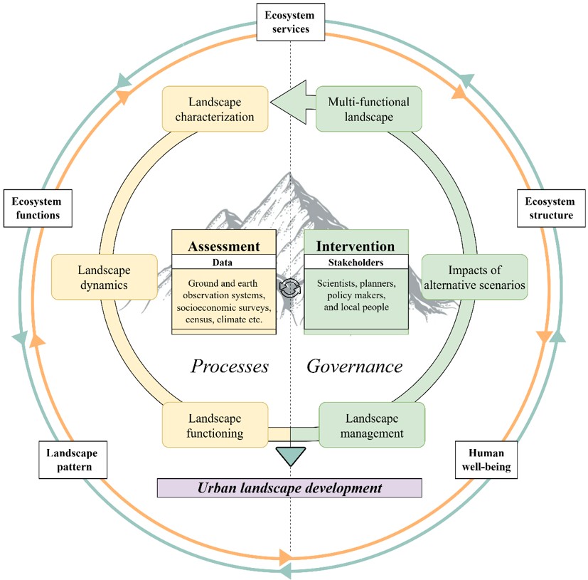
The framework operates as two interlocking steps: Assessment (understanding the system) and Intervention (shaping future outcomes).
Together, they produce a single output: urban landscape development that is ecologically grounded and governance-ready.
Step 1: Assessment — Understanding What the Landscape Is Doing
Assessment is about building a grounded understanding of how the landscape has evolved and how it functions today — both structurally and ecologically.
Landscape characterisation
Defines the functional extent of the landscape using ecological and socioeconomic boundaries, rather than administrative units. Multi-source datasets (remote sensing, field observations, institutional data) are integrated to produce a consistent, long-term LULC record. This creates a spatiotemporal baseline for understanding landscape change. See the LULC Change project.
→ Defines what the landscape is, across space and time
Landscape dynamics
Analyses how the landscape is changing. Urban expansion is quantified (rate, intensity, spatial pattern), and linked directly with shifts in ecosystem service supply.
This is where urban growth and ecological function are analysed together, revealing how key ecosystem services are impacted in response. See the Ecosystem Services project
→ Explains how the landscape operates and evolves
Landscape evaluation
Assesses whether the landscape can continue to support urban growth. Hotspot–coldspot mapping of regulating ecosystem services identifies high-value ecological areas and zones most vulnerable to degradation. This step provides a spatial basis for conservation, restoration, and nature-based solutions (NBS). See the Ecosystem Services project.
→ Identifies where development is viable—and where it is not
Step 2: Intervention — From Evidence to Action
Intervention translates landscape evidence into actionable planning strategies.
Landscape management
Develops alternative development pathways based on ecological capacity, planning needs, and stakeholder input where possible. Climate change projections are integrated to ensure plans remain realistic under future mountain conditions. See the Urban Growth Scenarios project.
→ Defines how the landscape could be transformed
Impacts of alternative scenarios
Quantifies what each pathway delivers. Ecosystem service supply is mapped across scenarios, making trade-offs between development and ecological function explicit and measurable. This step turns abstract futures into comparable outcomes, enabling informed decision-making. It also identifies where targeted NBS can offset unavoidable impacts. See the Ecosystem Services project.
→ Reveals the consequences of each planning choice
Multi-functional landscape design
Integrates all findings into a balanced, decision-ready strategy. Development is aligned with ecological capacity—supporting growth where the system can absorb it, and protection where it cannot.
If needed, scenarios are iteratively refined until a workable balance is achieved.
→ Delivers a spatial strategy ready for planning and policy integration
Three Projects. One Loop.
LULC Change — the evidence base. Twenty years of species-level land cover across Dharamshala and Pithoragarh.
Ecosystem Services — the ecological stakes. Flood regulation, carbon, soil erosion, and heat mitigation mapped and hotspot-identified.
Urban Growth Scenarios — the futures. Three pathways to 2040 with quantified ecosystem consequences for each.
No single project covers the full loop. Together they do.