Compound Hazard Zones in Himalayan Cities
Where Defences of Nature Fail Together — and What That Means for Mountain City Planning
The problem
Urban risk frameworks treat floods, soil erosion, and heat stress as separate hazards — mapped by separate agencies, addressed by separate budgets. But mountain cities don’t face one hazard at a time — and these hazards don’t fail independently. They share common natural and anthropogenic drivers. Steep slopes, fragile geology, and monsoon rainfall mean these hazards are structurally coupled long before urbanisation begins. A slope that sheds water fast also erodes fast. So, the biophysical baseline is already precarious.
Urbanisation then amplifies what nature has already made vulnerable. Urbanisation-induced land cover changes accelerates runoff, destabilises slopes, replaces cooling vegetation with heat-retaining surfaces. The same patch of land loses its flood buffer, its erosion shield, and its cooling function at once. This is not coincidence. It is a consequence of building in landscapes where natural and human drivers of risk point in the same direction.
This project asks: Where do these hazards converge, and What does that mean for planning?
Framework: Regulating Ecosystem Service loss as multi-hazard proxy
In mountainous regions, Regulating Ecosystem Services play crucial roles in moderating the extreme events (like natural disasters) and mitigating the climate change impacts. Hence, rather than modelling each hazard separately, this project uses regulation ecosystem services (RES) as spatially explicit proxies for natural hazard buffering capacity. Where a service is low, the landscape has lost its ability to buffer that hazard — and that loss is mappable, measurable, and actionable.
| Ecosystem service | Hazard it buffers | Coldspot means |
|---|---|---|
| Flood Regulation (FR) | Fluvial flooding | Elevated flood hazard |
| Soil Erosion Regulation (SER) | Landslide and erosion risk | Elevated erosion hazard |
| Local Climate Regulation (LCR) | Urban heat stress | Elevated heat hazard |
| Carbon Sequestration (CS) | Ecosystem degradation | Supporting indicator |
Compound risk zones emerge where coldspots of multiple services spatially overlap — here the landscape has simultaneously lost its flood buffer, erosion shield, carbon sinks, and cooling function.
Step 1 — Four hazard proxies
I modelled and mapped all four RES across Dharamshala and Pithoragarh at four time points and identified statistically significant spatial clusters of high-value (hotspots) and low-value (coldspots).
→ View hotspot and coldspot maps for all four services
Step 2 — Where hazards converge: the compound risk map
Overlaying the four maps reveals two planning-critical zone types:
- EPCS — Ecological Priority Conservation Sites: where multiple service hotspots overlap. Nature’s defences are intact — the landscape’s remaining protective buffers.
- EPRS — Ecological Priority Restoration Sites: where multiple service coldspots overlap. These are the compound hazard zones — simultaneously exposed to elevated flood, erosion, low carbon sinks, and heat risk.
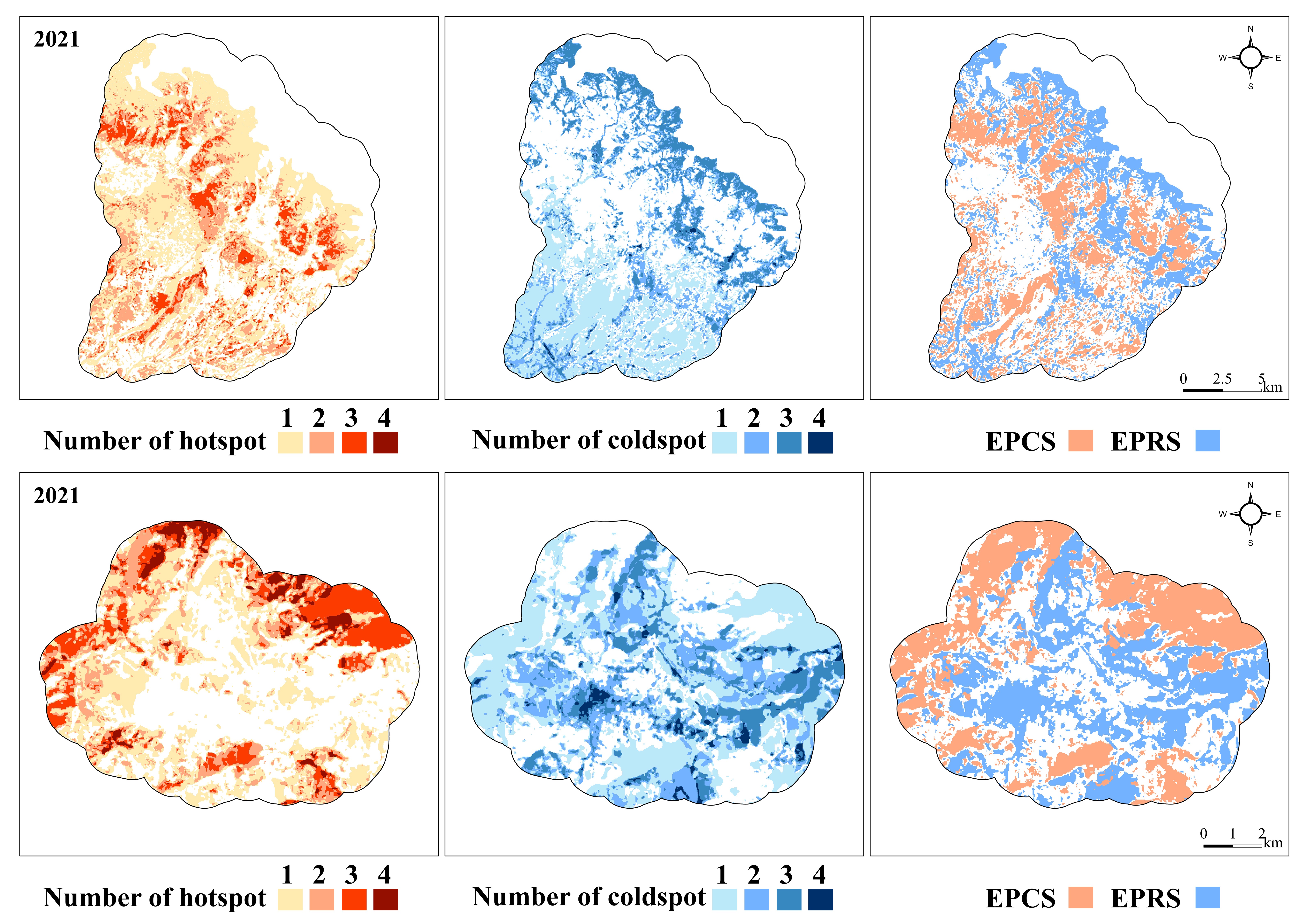 Compound hazard zones (EPRS, blue) and conservation priority zones (EPCS, orange)
Two cities, two spatial stories
Dharamshala presents a trade-off landscape.
The most severely degraded areas sit in two distinct parts of the city: barren land at higher elevations where multiple protective capacities have eroded together, and built-up patches at lower elevations where urban expansion has replaced the flood and erosion buffer simultaneously. The landscape still has more intact buffers than degraded ones — but the margin is narrowing.
Pithoragarh tells a different story.
The city core — dense built-up land — sits at the heart of the compound hazard zone, where all four ecosystem services have collapsed together. Compound hazard zones have overtaken conservation zones by area. The landscape has already bifurcated: one zone that needs protecting, and a separate zone that urgently needs restoring. There is no trade-off left to navigate.
What this means for planning
Identifying compound hazard zones is only useful if it changes what gets built, protected, or restored — and where.
| Zone | Status | Planning response |
|---|---|---|
| EPCS | Multiple ecosystem buffers intact | Protect — buffer zone designation, development controls |
| EPRS | Multiple hazards converging | Restore — nature-based solutions, green infrastructure, targeted NbS investment |
The spatial evidence exists at the resolution planners need. How this translates into governance-ready strategies — from landscape assessment to scenario-based decision-making — is detailed in the Planning Framework for Mountain Cities.
Key finding
More ecosystem service data does not automatically mean better urban risk decisions.
The bottleneck is the translation: from individual hazard maps to compound risk zones, and from compound risk zones to spatially explicit intervention priorities.
Mountain cities are not just facing more frequent hazards. They are facing simultaneous ones — in the same places, driven by the same process: unplanned urban growth eroding the natural systems that once provided protection.